|
|
The Paracel Islands are surrounded by productive fishing grounds and by potential oil and gas reserves. In 1932, French Indochina annexed the islands and set up a weather station on Pattle Island; maintenance was continued by its successor, Vietnam. China has occupied the Paracel Islands since 1974, when its troops seized a South Vietnamese garrison occupying the western islands. China built a military installation on Woody Island with an airfield and artificial harbor. The islands also are claimed by Taiwan and Vietnam.
|
|
|
|
|
|
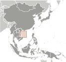
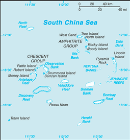
Southeastern Asia, group of small islands and reefs in the South China Sea, about one-third of the way from central Vietnam to the northern Philippines
|
|
|
|
|
16 30 N, 112 00 E
|
|
|
|
|
|
|
|
|
|
total: ca. 7.75 sq km
land:
ca. 7.75 sq km
water:
0 sq km
|
|
|
|
|
NA
|
|
|
|
|
0 km
|
|
|
|
|
518 km
|
|
|
|
|
NA
|
|
|
|
|
tropical
|
|
|
|
|
mostly low and flat
|
|
|
|
|
lowest point: South China Sea 0 m
highest point:
unnamed location on Rocky Island 14 m
|
|
|
|
|
none
|
|
|
|
|
arable land: 0%
permanent crops:
0%
other:
100% (2005)
|
|
|
|
|
0 sq km
|
|
|
|
|
typhoons
|
|
|
|
|
NA
|
|
|
|
|
composed of 130 small coral islands and reefs divided into the northeast Amphitrite Group and the western Crescent Group
|
|
|
|
|
|
no indigenous inhabitants
note:
there are scattered Chinese garrisons
|
|
|
|
|
NA
|
|
|
|
|
|
conventional long form: none
conventional short form:
Paracel Islands
|
|
|
|
|
|
The islands have the potential for oil and gas development. Waters around the islands support commercial fishing, but the islands themselves are not populated on a permanent basis.
|
|
|
|
|
|
1 (2010)
country comparison to the world: 229
|
|
|
|
|
total: 1
1,524 to 2,437 m:
1 (2010)
|
|
|
|
|
small Chinese port facilities on Woody Island and Duncan Island
|
|
|
|
|
|
occupied by China, also claimed by Taiwan and Vietnam
|
|
|
|

