


| The World Factbook | ||
|
|
Palmyra Atoll |
|
|
| Introduction | Palmyra Atoll |
|
Background:
|
The Kingdom of Hawaii claimed the atoll in 1862, and the US included it among the Hawaiian Islands when it annexed the archipelago in 1898. The Hawaii Statehood Act of 1959 did not include Palmyra Atoll, which is now privately owned by the Nature Conservancy. This organization is managing the atoll as a nature preserve. The lagoons and surrounding waters within the 12 nautical mile US territorial seas were transferred to the US Fish and Wildlife Service and were designated a National Wildlife Refuge in January 2001. |
| Geography | Palmyra Atoll |
|
Location:
|
Oceania, atoll in the North Pacific Ocean, about half way between Hawaii and American Samoa |
|
Geographic coordinates:
|
5 52 N, 162 06 W |
|
Map references:
|
Oceania |
|
Area:
|
total: 11.9 sq km
water: 0 sq km land: 11.9 sq km |
|
Area - comparative:
|
about 20 times the size of The Mall in Washington, DC |
|
Land boundaries:
|
0 km |
|
Coastline:
|
14.5 km |
|
Maritime claims:
|
territorial sea: 12 nm
exclusive economic zone: 200 nm |
|
Climate:
|
equatorial, hot, and very rainy |
|
Terrain:
|
very low |
|
Elevation extremes:
|
lowest point: Pacific Ocean 0 m
highest point: unnamed location 2 m |
|
Natural resources:
|
terrestrial and aquatic wildlife |
|
Land use:
|
arable land: 0%
permanent crops: 0% other: 100% (forests and woodlands) (2001) |
|
Irrigated land:
|
0 sq km (1998 est.) |
|
Natural hazards:
|
NA |
|
Environment - current issues:
|
NA |
|
Geography - note:
|
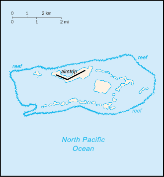
about 50 islets covered with dense vegetation, coconut trees, and balsa-like trees up to 30 meters tall |
| People | Palmyra Atoll |
|
Population:
|
no indigenous inhabitants; 4 to 20 Nature Conservancy staff, US Fish and Wildlife staff (July 2005 est.) |
| Government | Palmyra Atoll |
|
Country name:
|
conventional long form: none
conventional short form: Palmyra Atoll |
|
Dependency status:
|
incorporated territory of the US; privately owned, but administered from Washington, DC, by the Fish and Wildlife Service of the US Department of the Interior; the Office of Insular Affairs of the US Department of the Interior continues to administer nine excluded areas comprising certain tidal and submerged lands within the 12 nm territorial sea or within the lagoon |
|
Legal system:
|
the laws of the US, where applicable, apply |
|
Flag description:
|
the flag of the US is used |
| Economy | Palmyra Atoll |
|
Economy - overview:
|
no economic activity |
| Transportation | Palmyra Atoll |
|
Highways:
|
most of the roads and many causeways built during World War II are unserviceable and overgrown (2001) |
|
Ports and harbors:
|
West Lagoon |
|
Airports:
|
1 (2004 est.) |
|
Airports - with unpaved runways:
|
total: 1
1,524 to 2,437 m: 1 (2004 est.) |
| Military | Palmyra Atoll |
|
Military - note:
|
defense is the responsibility of the US |
| Transnational Issues | Palmyra Atoll |
|
Disputes - international:
|
none |
|
This page was last updated on 17 May, 2005 |